![]()
Alaska Highway 2013
 Well here we are packing up the family RV for another round trip adventure over those mesmerizing
roads we refer to as the Alcan Highway. Even after 30 years of driving this highway we find
that the excitement still generates plenty of anticipation as the past memories summon up happy
days and the beginnings to many new friendships. There has always been something special about
the Alaska Highway and the people that live, work and travel to this enchanting destination.
The Alaska Highway remains a journey that can be explored many times over and still there remains
plenty left undiscovered.
Well here we are packing up the family RV for another round trip adventure over those mesmerizing
roads we refer to as the Alcan Highway. Even after 30 years of driving this highway we find
that the excitement still generates plenty of anticipation as the past memories summon up happy
days and the beginnings to many new friendships. There has always been something special about
the Alaska Highway and the people that live, work and travel to this enchanting destination.
The Alaska Highway remains a journey that can be explored many times over and still there remains
plenty left undiscovered.
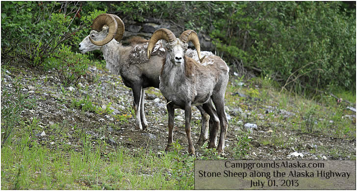
The Alcan, Alaska/Canada, road trip traverses the historical route linking the 49th state with the railroads of Canada and on to the remainder of the lower 48 states. Built during the early stages of WWII, this road is nothing short of a engineering miracle.
- 2013 Alaska Highway Road Conditions
- 2013 Alaska Highway Camping Report
Driving the Alcan Highway in 2013
Driving the Alaska Highway in 2013 we noted some important differences from last years trip. First off, the roads in B.C. and the Yukon are in much better shape, this could be due to the later start we got this summer. Also we note an increase in traffic especially in RV's doing the popular Canada Circle Loops that we will discuss in further detail as time permits.
Campers can now pick up a pretty comprehensive and totally free Alaska Highway Map at the visitors centers in Dawson Creek and Beaver Creek as well as many points in between. Actually there are two free Alaska Highway Maps that cover this route. The first is the Northern British Columbia Map, we picked ours up at the visitors center located at the turnoff for Mackenzie on Highway 97. The second is free Yukon Highway Map that we picked up at the historic roadhouse of Contact Creek on the B.C. Yukon border.
;